By Marty Morgan
Throughout World War II the Allies enjoyed a certain advantage over the Axis that was purely the product of geography. Because the Allied nations occupied real estate on both sides of the Atlantic Ocean, their meteorologists were able to benefit from communicating with one another about weather patterns.
[text_ad]
Prevailing weather patterns in the Northern Hemisphere generally move from west to east. During World War II this meant that a weather station in Canada could observe a particular weather event and then pass that information on to a station in Iceland, which would in turn pass it on to British meteorologists on the other side of the Atlantic. Thus, the Canadians could tell the British what kind of weather was on its way to Europe.
On countless occasions, this information was decisive in helping the Allies operate with valuable information as to climatic conditions. Conversely, the German Navy, or Kriegsmarine, enjoyed no such advantage since its meteorologists could reach no farther west than France’s Bay of Biscay coastline. During the early years of the war, this issue did not present such a problem because Kriegsmarine U-boats and surface vessels all over the world enjoyed a terrific operational advantage and were capable of sending in weather reports.
A New Wehrmacht Weather Strategy
The German Navy’s dominance slipped as the war developed; and, as the hunter became the hunted, it transitioned from the offensive to the defensive. In the defensive and reactive mode, accurate weather forecasting became more critically important than ever to Germany.
The need to fill this weather gap led the German military to explore the idea of establishing secret weather stations on the North American continent. During the latter half of 1943, the German Meteorological Service developed the design for a weather station that could be deployed to remote Arctic islands around Greenland. Produced by the Siemens Corporation, the design was completely automated, portable, and capable of being packed through the narrow hatches of a U-boat.
Choosing a Location
After tests of the prototype resulted in an initial success, the Abwehr, German intelligence, decided to deploy a station to a remote area of northern Canada. Shortly thereafter, the submarine U-537 departed Kiel on Germany’s Baltic coast with a station aboard. After calling briefly in Bergen, the U-boat departed on September 30, 1943, and continued toward its destination, the Labrador coast of Canada. The timing of this mission was critical and called for the station to be deployed in late October while the coastal inlets near Cape Chidley remained unfrozen. Shortly after the mission was to be completed, those inlets would freeze over with the coming winter, making it all the more unlikely that the Canadian authorities would either locate or dismantle the station.
The area chosen for the weather station was so extremely remote that it had only recently been surveyed. In 1931, the National Geographic Society had launched a program to survey coastal Labrador. According to the society, the survey also sought “to carry out the field work necessary for testing the new method of producing topographical maps from oblique aerial photographs.”
Using a Fairchild seaplane equipped with the most modern cameras available at the time and a supporting research ship, the survey crew began working each summer season when the weather cooperated. Working its way north with each season, the survey’s ultimate destination was Killiniq Island where the Labrador Sea meets Ungava Bay.
An “Excellent and Probably Hitherto Unexplored Harbor”
The east coast of the Labrador Peninsula is dominated by hundreds of fractured fjords, inlets, and treacherous shoals. Cape Chidley itself was later described as being “steep and bold on all sides,” by a member of the team. To a large degree, the intense nature of this coastal geography was responsible for the lateness of an official and organized survey expedition. Even before the National Geographic team reached as far north as Killiniq Island and the infamous rocky cape located there, an interesting discovery was made.
In 1934, a ship captain anchored in “an excellent and probably hitherto unexplored harbor about seven miles south of Cape Chidley.” Locating and charting that harbor was one of the many objectives of the National Geographic survey because it could serve as a safe anchorage for the regular shipping traffic traveling between the St. Lawrence River and the commercial markets of Europe.
In 1935, the survey team explored and charted the area near Rowland Point, the Hutton Peninsula, and the mouth of the Ikkudliayuk Fjord. What the survey found there was an anchorage with a natural depth of as much as 42 feet between the east coast of the Hutton Peninsula and the lee of Oo-olilik Island. It was called Attinaukjuke Bay or Martin Bay, and it was the “excellent and probably hitherto unexplored harbor” identified in 1934. It was also the destination of U-537 in October 1943.
U-537 Departs
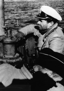
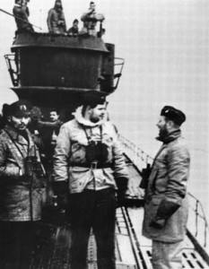
When Kapitanleutnant zur See Peter Schrewe steered U-537 out of Bergen at the beginning of that month, he had no way of knowing what danger and excitement the next three weeks would hold. He was in command of 48 men on a Type IXC/40 U-boat, which had been manufactured by Deutsche Werft AG in Hamburg between April 1942 and January 1943. The 87 IXC/40 U-boats commissioned into Kriegsmarine service during World War II represented an improvement over the earlier Type IXC boats.

The improvements largely related to increased fuel-carrying capacity, which increased overall cruising range to approximately 13,850 nautical miles, and enhanced antiaircraft armament. In addition to the single-mount 20mm Type 30 flak gun on the tower superstructure, the IXC/40s were upgunned with the addition of a platform aft of the tower that accommodated a Flakvierling 38. This weapon was a flexible quadruple 20mm antiaircraft gun mount that more than doubled the Type IXC’s ability to defend itself against aerial threats. With four weapons simultaneously firing 20mm projectiles at a cyclic rate of 450 rounds per minute, the Flakvierling 38 was capable of a practical cumulative cyclic rate of fire of over 1,800 rounds per minute. In other words, it was a weapon that could put a lot of lead in the sky at one time against an attacking airplane, and it made the IXC/40 an extremely dangerous target.
When U-537 departed Bergen, the submarine’s route took it west across the North Sea. Between the Faroe Islands and Iceland, the U-boat entered the northern stretches of the Atlantic Ocean. This route was far less traveled and promised a somewhat safer Atlantic crossing than the more heavily patrolled shipping lanes farther to the south. Dutifully, U-537 transmitted a message to U-boat headquarters announcing that it had crossed 20 degrees west longitude.
Counter-Intelligence
British cryptanalysts at Bletchley Park near London intercepted that message and a series of others that followed. In connection with the mission to deliver the weather station to the Labrador coast, Schrewe had been ordered to radio in at prescribed points along the way to receive instructions. One of those points was 20 degrees west.
The following afternoon, Schrewe was instructed: “onward passage in accordance with special task.” Once again, although the British intercepted and read the message, they had no idea what the “special task” was. The “onward passage” part of the message meant that U-537 was to continue en route to Canada. The U-boat then entered a truly wretched patch of foul weather characterized by high winds, strong rain, and extreme cold temperatures, resulting in several of the crew becoming terribly seasick. The storm also had the effect of slowing the progress of the boat to a crawl.
Schrewe also received a rather complicated set of instructions directing the U-boat “to simulate a battle group” in a specified area by surfacing intermittently and broadcasting false wireless transmitter traffic in the form of daily weather reports. After sending one wireless message, he was ordered to submerge and move to another location and repeat the process a few dozen times. The whole ruse was designed to create the impression of a large Kriegsmarine naval task force operating in the area.
Losing the Flakvierling
Obediently following orders, Schrewe completed the mission as instructed despite the fact that conditions were appalling for all aboard each and every time the U-boat surfaced to send the radio report. When U-537 surfaced just after 2 pm on October 14, large swells pounded the boat. One of those swells struck with such power and violence that the Flakvierling 38, a 3,300-pound weapon, was ripped from its mounts and swept overboard.
When Schrewe transmitted a message informing U-boat headquarters of the incident, the reply questioned where the weapon had broken loose and whether or not it had been properly stowed. Schrewe responded to the questions, and the transmission was intercepted by Bletchley Park. The British, therefore, knew that U-537 was in the North Atlantic on a “special task” and that it had just lost its primary antiaircraft gun. It was valuable intelligence, but nothing could be done about it.
“Onward Passage to Execute Special Task.”
At 11:49 am on October 17, Schrewe surfaced in the North Atlantic at a prearranged location and transmitted his position as 59 degrees north, 48 degrees west, which placed U-537 in the Labrador Sea just off the southwestern tip of Greenland. The reply came at 11:53 am the following day and said simply, “onward passage to execute special task.” This represented the final order for the U-boat to approach to the Canadian coast. Schrewe and the crew of U-537 then continued on toward Cape Chidley.
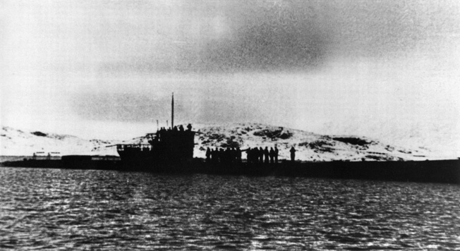
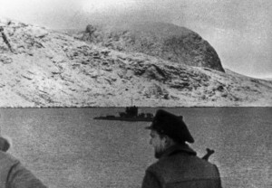
Because of the continuing foul winter weather, progress was slow and it took another four days for the U-boat to cover the distance. Early in the evening of October 22, 1943, U-537 anchored in Martin Bay. The crossing had been time-consuming and arduous, but it had been brought to its successful conclusion. Though the Flakvierling 38 had been lost, U-537 rode at anchor in protected water in North America, and it was time to complete the “special task” so cryptically mentioned in the transmissions from headquarters.
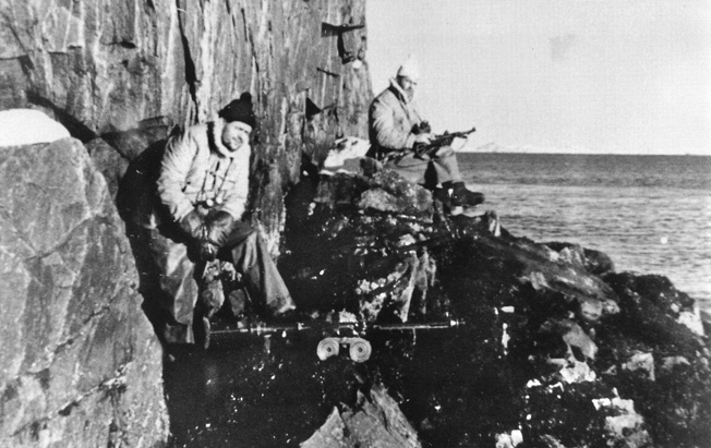
Schrewe immediately sent a party ashore to post a lookout and scout a site for the weather station. When the Kriegsmarine shore party landed on the beach on the Martin Bay side of the Hutton Peninsula, it represented the one and only time that the military forces of National Socialist Germany conducted an armed landing in the Americas. A machine gun was placed on the heights overlooking the bay to provide some measure of protection and early warning for the U-boat riding at anchor in the cove below. A clear spot on the summit of a 170-foot hill 400 yards inland from the beach was selected for the site of the station.
Setting up the Station
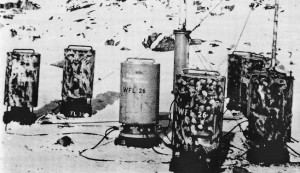
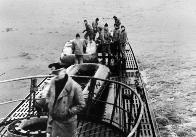
At dawn on October 23, the daylong process of installing the device began. The package was a Wetter-Funkgerät Land-26 (WFL-26), nicknamed Kurt by its designer. It consisted of several pieces, including a 10-meter-tall mast mounting an anemometer, a tripod for the mast, and 10 cylinders containing other weather instruments as well as a 150-watt transmitter and dry cell, high-voltage batteries. Once assembled, Kurt would record temperature, humidity, air pressure, wind speed, and wind direction data and transmit that information to receiving stations in northern Europe every three hours. The assembly and installation of Kurt was not completed by U-boat sailors but by Professor Kurt Sommermeyer from Siemens.
Along with two technicians, Professor Sommermeyer had accompanied U-537 on its rather uncomfortable and unpleasant Atlantic voyage. First thing in the morning on the 23rd, the team went to work with the help of several sailors, getting the apparatus ashore and up to the top of the hill. Because each piece weighed 220 pounds, it took time and muscle to bring the cylinders up from the submarine and place them aboard the launch. which then delivered them ashore. More time and muscle were needed to move the cylinders from the beach to the hilltop site where Kurt would be assembled.
As soon as all of the pieces of the Kurt package were in position, Professor Sommermeyer and his technicians spent the rest of the day assembling and testing it. Each of the pieces of the WFL-26 station were marked “Canadian Weather Service,” which is noteworthy only because no such government entity existed at the time.
The Fate of Kurt
By late afternoon everyone was back aboard ship, which allowed U-537 to weigh anchor and depart at 5:40 pm. U-537 cruised out to sea far enough to submerge completely and then paused on the bottom long enough to confirm that the 150-watt Lorenz FK transmitter was broadcasting. Kurt was in place and functioning. Earlier that morning, Schrewe received a message from headquarters that instructed him as to what to do next: “On completion of task move off 300 miles and report execution by short signal. Then freedom of action in square Gruen UE and to eastward thereof.”
Schrewe insisted on periodically surfacing to check for a signal from Kurt, but there was nothing. Once again, Germany’s best efforts to gain an advantage had met with frustration. Not willing to accept defeat, the Kriegsmarine made another attempt the following season when a second Kurt was loaded aboard U-867 in early September 1944. With the plan that it would be installed in roughly the same area on the Labrador coast as the first Kurt, the U-boat would follow the same basic track that U-537 had the previous year. But U-867 never reached its destination. A Consolidated B-24 Liberator bomber from Royal Air Force No. 224 Squadron sank it northwest of Bergen on September 18.
The Abwehr seemed to be cursed with a run of very bad luck.
U-537 did not survive the war. The U-boat was sunk with all hands by torpedoes from the submarine USS Flounder in the Java Sea on November 9, 1944. It was later reported that Canadian authorities did not locate the remnants of the Kurt weather station until 1981.
Originally Published October 2010

As an avid reader of WW ll since the 1940’s I was not aware of any automated weather stations. This type of information I find to be very interesting.
David Seeds