By Jennifer F. McKinnon & Della A. Scott-Breton
Saipan’s shallow, tropical lagoons are a veritable waterpark for World War II enthusiasts who do not mind getting wet. Littering the seabed in water as shallow as a few feet or up to 35 feet lie aircraft, amphibious vehicles, ships, and tanks, all of which met their demise during the decisive Battle of Saipan in the Mariana Islands. The battle for control of the island began with aerial assaults followed by offshore bombardment, an amphibious invasion, and hand-to-hand combat lasting for about a month in June and July of 1944. These engagements have left a lasting legacy on the land and seascape of Saipan.
In 2009 an international team of archaeologists partnered with local marine management agencies in Saipan to create a World War II Maritime Heritage Trail. Heritage trails are great educational and tourism products that introduce the public and divers to the exciting underwater world of shipwrecks and other submerged cultural heritage. Underwater trails have been used for decades in places like Florida and Australia to promote and protect underwater cultural and natural sites through public engagement and education. Much like terrestrial parks and trails, underwater trails usually feature guides with educational components that highlight the history of sites and events, their importance, and how and why they are protected.
The island of Saipan, part of the United States’ Commonwealth of the Northern Mariana Islands, is a perfect location for an underwater heritage trail. Inhabited for thousands of years by the Chamorro people, the island still possesses evidence of their culture in the form of latte stone pillars for structures, ceramics, and other artifacts. Colonized by the Spanish in the 16th century, Saipan became home to immigrants from the Caroline and Philippine islands, German settlers, and Japanese industrialists before being claimed by the United States as a result of the World War II battle in 1944. All of these cultures are represented in Saipan’s archaeology, and the battle in particular left an amazing and poignant variety of relics in the lagoon and surrounding waters. Additionally, the clear, calm, blue water boasts a variety of marine life which now inhabits the sunken military vehicles, making Saipan a major diving destination.
The interpretation of Saipan’s underwater World War II heritage resources accomplishes several goals. The project to record and research the sunken craft was funded by a National Park Service (NPS) American Battlefield Protection Program grant, and the resulting information and public interpretation dovetails with the efforts of the existing NPS American Memorial Park to “honor the sacrifices made during the Marianas Campaign.” The project also enabled graduate student research into cultural heritage management and conflict site interpretation. The information products contribute to the island’s economy through enhanced opportunities for heritage tourism and to the island’s history through education of its citizens and visitors. With an eye toward long-term conservation and management, Saipan’s diving industry was engaged as active stewards of the sites, and diving operators were provided with underwater historic preservation training to help foster appreciation and protection.
The World War II Maritime Heritage Trail: Battle of Saipan consists of nine stops with 12 vehicles or vessels, including a Japanese Aichi E13A Jake floatplane, a U.S. Grumman TBM Avenger torpedo bomber, a Japanese Kawanishi H8K Emily flying boat, a U.S. Martin PBM Mariner flying boat, two Japanese Daihatsu Landing Craft, a U.S. LVT(A)-4 (landing vehicle, tracked), a Japanese freighter, three U.S. M4 Sherman medium tanks, and a possible Japanese auxiliary submarine chaser.
The Aichi E13A was a single-engine, twin-float, long-range reconnaissance seaplane that made its combat debut in 1941. The Imperial Japanese Navy (IJN) operated more aircraft of this type than any other during World War II. This aircraft participated in a number of significant operations, including reconnaissance patrols over Pearl Harbor. Operated by a crew of three, the Jake could carry a 550-pound bomb load. Located in 23 feet of water, this Jake lies upside down, and many of its features are still intact. Clues to the aircraft’s demise may be found near the tail section, where bullet holes and an odd crimped area suggest battle damage and possible salvage or disposal attempts. The study of archaeology can reveal interesting clues as to its demise and is particularly relevant because postbattle activities are scarce in historical documentation. After carefully mapping the site, archaeologists surmised that the aircraft may have been towed or barged out to the site and discarded. Alternatively, the crimped area could have been an attempt to recover the sunken craft. The plane rests alone in a white sand field, providing a home for fish, corals, and sponges. Schools of colorful fish hide in the shadows of an exposed wing.
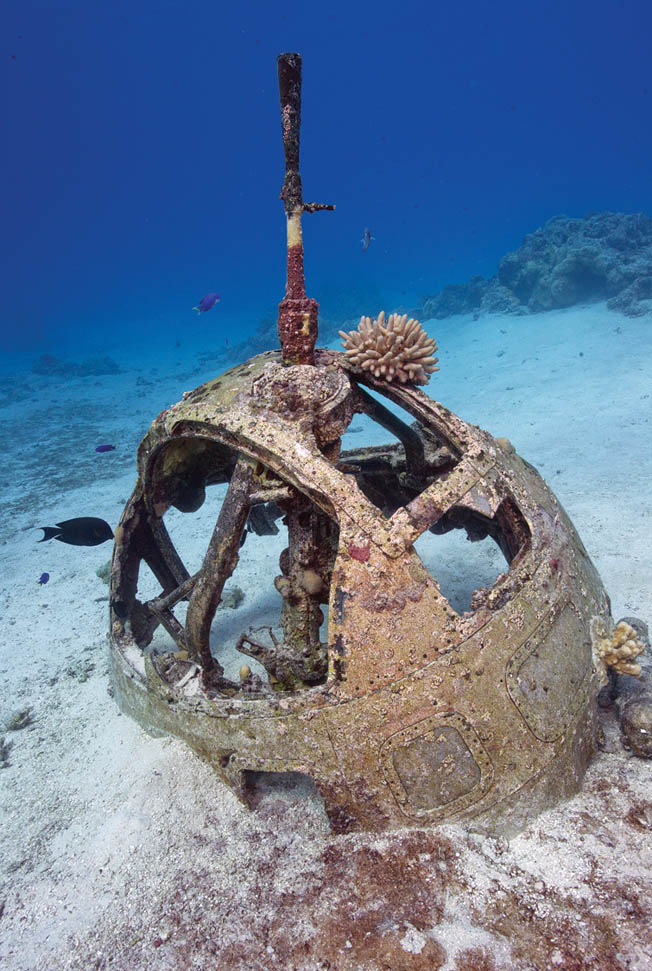
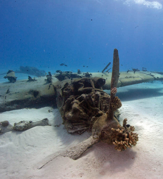
On the edge of Saipan’s fringing reef, a TBM Avenger sits in about 13 feet of water. The Avenger was the most widely produced naval strike aircraft in history. Avengers had three to five crewmen and could carry 1,600 pounds of torpedoes or other munitions. Avengers played a significant role in the Battle of Saipan, participating in preinvasion bombing and strafing attacks, air support for ground troops, antisubmarine patrols, and reconnaissance missions. Avengers assigned to Vice Admiral Marc Mitscher’s Task Force 58 flew numerous sorties in the Battle of the Philippine Sea. The last TBMs retired from military service in 1962. Due to the Avenger’s position on the reef top in a dynamic environment, little is left of the aircraft except its frame. Upside down, its landing gear struts are fully extended, indicating it had just taken off or was attempting to land. One hypothesis is that the plane was damaged in the battle and perhaps the pilot was trying to land on the shallow, relatively flat reef. The landing gear break the surface of the water at low tide, making the site easy to locate. The main draw for this dive or snorkel is the gorgeous coral reef that surrounds the site like a vibrant, colorful garden.
The Kawanishi H8K is one of the most visited dive sites in Saipan, resting in 29 feet of water. Its frame is upside down, and it is scattered over a wide area. Recognizable features include all four engines and propellers, the nose turret with machine gun still in place, part of the cockpit with the pilot’s seat and controls, and sections of red and gray painted fuselage. Japanese and Korean monuments are located on the site as solemn reminders of those who lost their lives. The pilot’s seat, once intact, now is lying flat, a casualty of divers trying to sit in it and a stark example of the need for preservation of these sites. The four enormous propellers are scattered around the fuselage and make dramatic backdrops for underwater photographs. The H8K was a large, four-engine Japanese flying boat. Used in Pacific operations for reconnaissance, bombing, and transport, it was considered the backbone of the IJN’s maritime reconnaissance service. It earned a reputation among Allied forces as one of the hardest aircraft to shoot down due to its speed. With a crew of 10, it was armed with nose, dorsal, and tail machine guns.
The Martin PBM Mariner was a U.S. twin-engine flying boat dubbed the “Fighting Flying Boat” in reference to its heavily armed reconnaissance duties. The Mariner preovided many important support services during the war, including reconnaissance, patrol, troop and cargo transport, and rescue missions. In fact, these aircraft were important for post-battle operations around Saipan and the nearby island of Tinian as they ran “Dumbo” missions to recover downed Boeing B-29 bomber crews. The Mariner lies upside down in 23 feet of water and its debris field is scattered across 300 feet. Recognizable features include the central dihedral (angled) wing and two machine-gun turrets. These combined features allowed archaeologists to identify this previously unknown and little visited site. Because few divers visit the plane, artifacts still may be seen, such as piles of ammunition, plexiglass gun turret hatches, and control panel facings. These kinds of easily portable items often are removed from wreck sites by uninformed divers seeking souvenirs. Seeing them in place on the Mariner is a surprising and sobering reminder of the fierce struggle for Saipan.
Two Japanese Daihatsu landing craft sit in close proximity to each other in about 35 feet of water in Tanapag Harbor. These two landing craft are examples of how archaeologists can use historical documents, field research, and site investigations to link the underwater remains of craft with specific engagements. During the Battle of Saipan an amphibious counterattack was launched by Japanese forces using landing craft. Several craft loaded with soldiers were launched from the seaplane base to make a surprise attack farther along the coastline. However, they were discovered by U.S. forces and eventually sunk. These two landing craft are in the exact recorded location where the vessels were supposedly sunk, thus linking them with the counterattack as well as verifying U.S. combat operation reports. The Daihatsu class was a large motorized boat used by the Japanese Special Naval Landing Force. Powered by a diesel engine, it had a relatively long range for its size. The catamaran hull with a bow ramp allowed it to navigate in shallow water and easily offload troops. These features are clearly visible on one of the trail sites, while the other is more degraded with a collapsed hull.
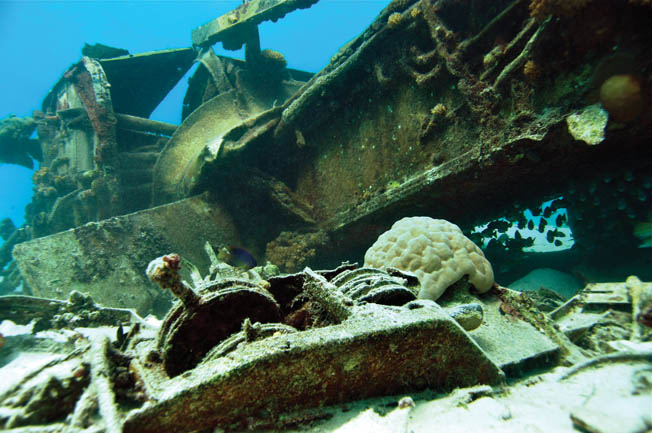
The U.S. LVT(A)-4 eventually earned the name “Marianas Model” due to the modifications crews made to the craft in the Mariana Islands. The LVT that lies in Saipan’s lagoon in 10 feet of water is a perfect example of those adaptations. After careful investigation, archaeologists noted that this LVT displays in-field battle modifications including an added gun, a makeshift boilerplate shield for the .50-caliber gun, and added boilerplate meant to protect the bow from the sharp coral reef over which the vehicles traversed. LVTs (also called amtraks) were amphibious tractors initially used in ship-to-shore cargo and troop movement, although they quickly evolved into assault and fire support vehicles. They were capable of traveling through the water and crossing shallow reefs, which made them critical to the amphibious invasion of Saipan. After the initial landing, LVTs performed critical missions during the battle, carrying supplies inland and extracting wounded soldiers. The trail LVT is located just off the Japanese seaplane ramp. Its hull is nearly intact with its stern buried in sand, although the turret is sunk into the deck below and the 75mm howitzer has been removed. The added .30-caliber machine gun port now shelters lionfish and wrasse, and the site is a nursery for small fish.
Nearly two dozen merchant vessels were sunk in Saipan’s waters during World War II. The Japanese freighter site is thought to be the remains of Shoan Maru, a steamer of 5,624 gross tons built in 1937 and later requisitioned for use in the war. Lying on its starboard side in 35 feet of water, it was heavily damaged in the battle when it was torpedoed offshore. Towed into the lagoon for repairs, it was further damaged by aerial assaults that caused it to sink on its anchor. It also was heavily salvaged after the battle, and archaeologists have noted the telltale signs of metal cutting on the hull and deck of the ship. Interestingly, this ship is suspected to have served as a target for secret CIA demolition training that was carried out on the island in the late 1940s. The site has a Korean monument to commemorate the conscripted Korean soldiers it was carrying at the time it was damaged. The stone block, carved with an inscription, is regularly cleaned by visiting divers to keep it legible.
Perhaps the most striking remnants of the Battle of Saipan, three M4 Sherman medium tanks, sit partially submerged just off the invasion beaches on the southwest side of the island. Visible from shore, these sites offer excellent swim or snorkel outings, particularly for those who do not dive. The M4 Sherman was the primary tank used by the U.S. Army and Marine Corps in World War II. It was operated by a crew of five, and early variants mounted 75mm guns. During the attack on Saipan, the M4s proved victorious against Japanese tanks in the largest tank battle of the Pacific Theater. Of the three sitting offshore, one is a “wet” variant, indicating the ammunition was stowed wet surrounded by a glycol liquid. The switch from dry to wet stowage was an important safety improvement because the dry bins tended to explode when hit by enemy fire. Although rusting from exposure to the sea, the trail tanks are solid and sturdy, providing a chance for visitors to peer inside the turrets and swim around the tracks and armored sides.
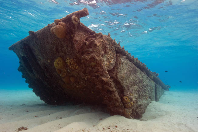
The last site featured on the trail is the most mysterious since its identity is truly unknown, although it is suspected to be an auxiliary submarine chaser. In 1931 the IJN ordered 64 purpose-built sub chasers, but they also later augmented their fleet by requisitioning more than 200 small merchant ships and pressing captured patrol boats and minesweepers into service. These vessels were used in the Pacific to patrol for submarines and to escort Japanese convoys. With its very sharp bow and sleek lines, this shipwreck closely matches the designs of polar whaling ships conscripted by the IJN for auxiliary submarine patrol. The ship is lying on its starboard side in approximately 30 feet of water on the sandy bottom. The sharp bow is clearly identifiable, but the remainder of the wreck is badly broken up. Interestingly, the aft and stern portions of the vessel are completely missing.
Archaeologists suspect that it was another secret CIA explosives training site, as well as the victim of postbattle salvage operations.
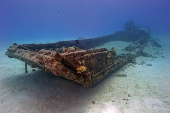
Each site on the trail has been interpreted through an underwater, waterproof dive guide that is available on island at several locations or for download at https://sites.ecu.edu/pmht/. Likewise, the sites are included in a poster series also available for download or on the island. Combined, these 12 sites comprise the World War II Maritime Heritage Trail: Battle of Saipan. They are representative of the entire operation on both sides. Some of the sites typify the specific Battle of Saipan in the Marianas, while others speak to the multiple ethnic groups that were involved in the war as combatants, noncombatants, and conscripts. The individual sites help tell the story of the battle and serve as important reminders of the history of World War II. They are tangible reminders of a staggering conflict that now, through their serene setting and continued life as artificial reefs, bring people of all nations together in recreation, remembering, and learning. Because of this significance, these sites are protected from disturbance by Federal and Commonwealth laws and regulations.
Shipwrecks, plane wrecks, and other historic underwater heritage sites are protected just like historical sites on land. They are considered nonrenewable resources. As such, the sites in Saipan’s lagoon are protected by several local and Federal laws, including the Sunken Military Craft Act of 2005, the Abandoned Shipwreck Act of 1987, the CNMI Historic Preservation Act of 1982, the Archaeological Resources Protection Act of 1979, and the National Historic Preservation Act of 1966. These laws protect archaeological sites on land and on submerged bottomlands from unauthorized disturbance, destruction, or removal of artifacts. They serve to protect our shared underwater heritage so that future generations may visit, learn from, and enjoy these unique examples of our dramatic history, national experience, and common heritage.
The Trail is open to the public year round and is free of charge. Visitors may choose their own adventure, seeing one or two sites or even all nine in a single day. Many are accessible by snorkel for the nondivers.
Authors Jennifer F. McKinnon, Ph.D., and Della A. Scott-Ireton, Ph.D. are with East Carolina University and the Florida Public Archaeology Network, respectively. This is their first contribution to WWII History.


Thank you for your narrative on these sites. I’m a diver, archeologist major, history buff and live in Saipan. It would be nice to include several photos for each site, so as to relate their historical significance when diving. Thanks again.
Hello Melissa,,I enjoy this site, but I am trying to find information on the ship broken in two off the Micro Beach area, its amazing, I spotted it today, my search shows its possibly a concrete ship from WWII, but I was hoping to find more, any thoughts? I found this via flying my drone this morning, I am hoping I see many things from the air ,,any thoughts would be appreciated
USS Asphalt
Melissa thanks for your comment. Check out more about the trail here: http://blog.ecu.edu/sites/pmht/. We had to update our website and domain.
I lived on Saipan from 1995 to 2000. That is where I researched my first book, Saipan: Oral Histories of the Pacific War.
I am curious about the Avenger near one of the reefs. Is it near Managaha Island? if it is, I might know something about it. It Was flown off the jeep carrier, Gambier Bay by a Lt. Halloran. He was shot down near Navy Hill on 17 June 1944, and although badly burned managed to crash-land on the reef. However, his two crewmen bailed out but never seen again. I have contact with the son of the pilot and the niece of one of the crew. They will be interested in knowing where this Avenger is located.
Hi Bruce! Very familiar with your book and have used it for years! The Avenger is located south of Managaha on the reef almost at the entrance to the channel. I’m familiar with Holloman’s crash scenario and had been in touch with his family as well some years ago. The wreck is either his or one other we’ve managed to track down a record for. We’ve worked on mapping that site for a number of years and the last time we went out we located the engine and propeller. Fascinating site! Here’s some more info on the trail: http://blog.ecu.edu/sites/pmht/
I am also a SCUBA diver (mainly for archaeology, but also sport). Is this underwater heritage park now open? I have been to Saipan several time (last in 2019), but have heard nothing about this underwater park until now.
Many thanks for any information you might provide.
Thanks for your interest Steven! You can find more information about the trail here: http://blog.ecu.edu/sites/jennifer-mckinnon/ It is really more of a self-guided trail. You can download the dive cards which have information about visiting the sites and the site numbers. Grab a boat or hire a charter and visit one or all of the sites. We’ve hit most of them in one day, but to really enjoy all sites it is probably a two or three day adventure.